One person’s cold is another person’s mild, but I can say this: There is a good chance that temperatures will remain at or above average for the next six weeks.
Looking at various teleconnections within the atmosphere, here is what we can expect.
La Niña Advisory continues
According to the Climate Prediction Center and NOAA/National Weather Service, “La Niña is likely to continue into the Northern Hemisphere spring and then transition to ENSO-neutral.”
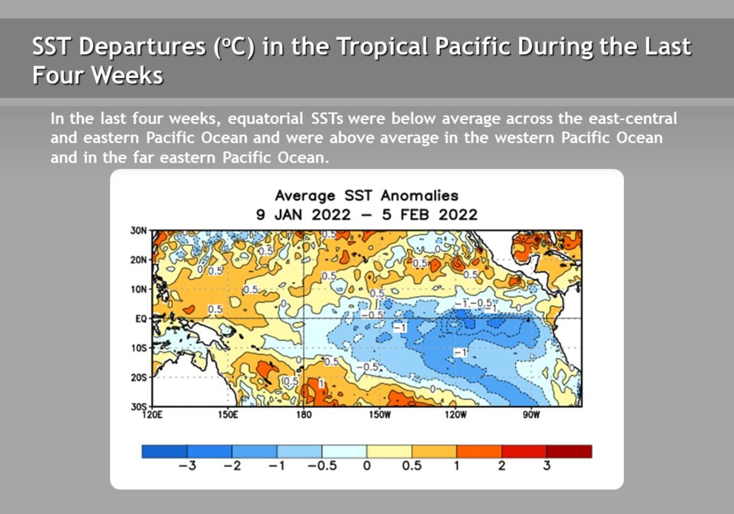
La Niña is the presence of abnormally cool water Pacific Ocean water temperatures along the coast of South America near the Equator.
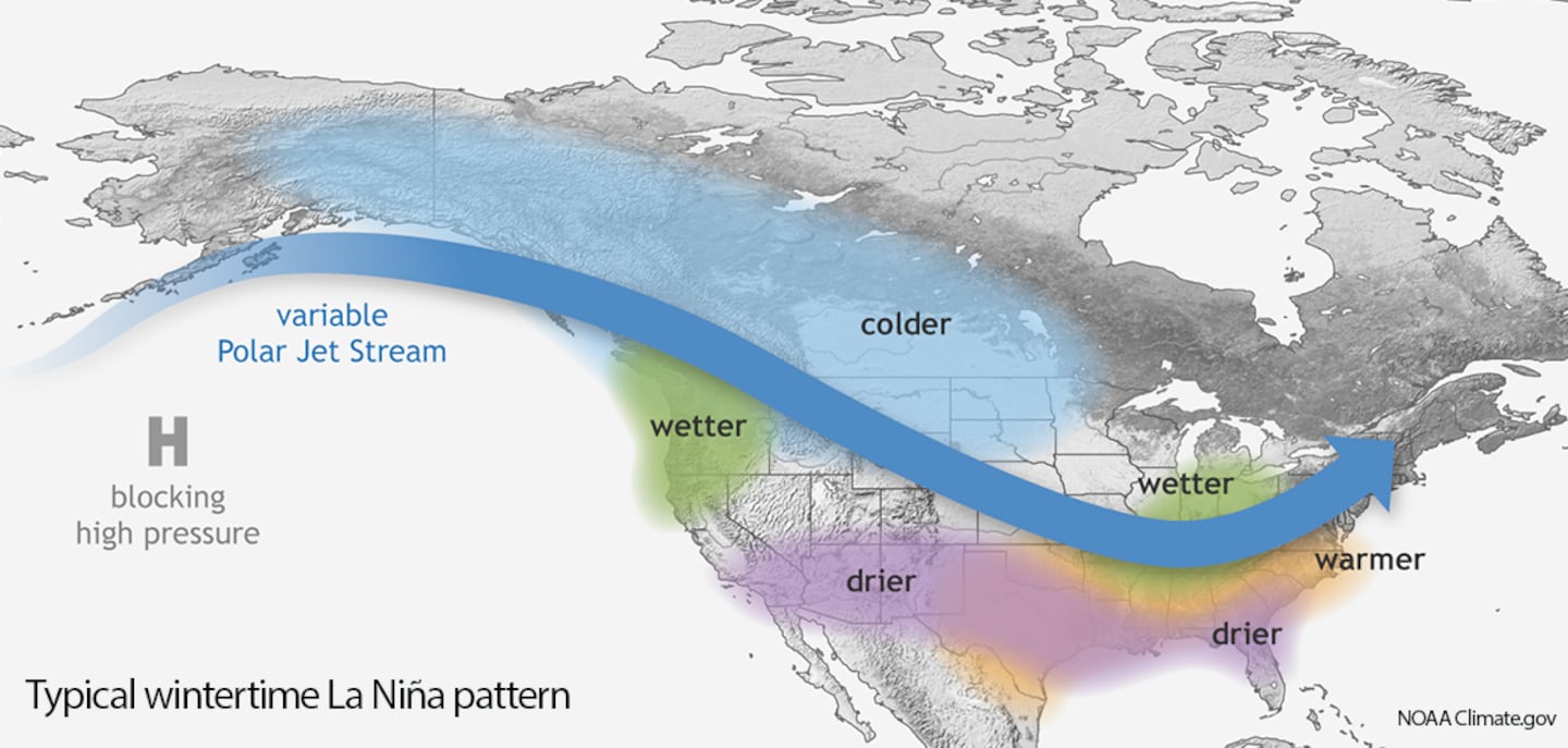
This abnormally cool water can impact the weather in North America by generating relatively warmer conditions for the Southeast U.S. South to Middle Georgia tend drier during La Niña, though North Georgia (including Metro Atlanta) can see wetter conditions.
But La Niña conditions can be present over numerous months, and indeed stretch from one year into another. So I check other teleconnections for more intraseasonal trends.
AO, NAO, PNA
Every week, I keep tabs on the following teleconnections because they also influence our winter weather in Metro Atlanta:
- Arctic Oscillation (AO) -- negative phase opens the door for cold air outbreaks in the Eastern half of the US. As of February 8, 2022, the Arctic Oscillation is weakly positive, and it is trending weakly negative.
- North Atlantic Oscillation (NAO) -- negative phase means colder air for the Eastern U.S. As of February 8, 2022, the North Atlantic Oscillation is positive now, and it is trending positive.
- Pacific North American Pattern (PNA) -- positive phase means colder air for the Eastern U.S. As of February 8, 2022, the Pacific North American Pattern is positive now, but is trending negative/neutral.
Don’t Forget the Madden Julien Oscillation!
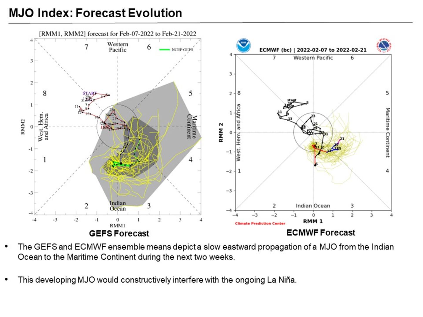
In addition to the teleconnections listed above, I also take a look at the Madden Julien Oscillation, or MJO.
The MJO is defined by NOAA as “an eastward moving disturbance of clouds, rainfall, winds, and pressure that traverse the Earth in the tropics and and returns to its initial starting point in 30 to 60 days, on average”.
The MJO consists of two phases: the enhanced rainfall, or convective phase as well as the drier phase. It can also be weak/inactive, which does not impact the US temperatures.
According to NOAA, an active MJO (phase 1 and 2) is associated with below average temperatures over much of the Continental U.S. Phases 5 and 6 are associated with above average temperatures.
During the month of January, the MJO remained fairly weak, with little to no eastward propagation.
However, as of February 8, 2022, the MJO is becoming active again, with a slow eastward propagation of the disturbance over the next two weeks. As a result, the MJO may “constructively interfere” with La Niña and help to enhance its temperature and rainfall impacts.
Conclusion: Mild Conditions For the Next 6 Weeks
As of February 8, 2022, the MJO is becoming active again and will likely help enhance La Niña conditions. In addition, the AO, NAO and PNA are cancelling each other out, which leads me to think that the prevailing teleconnection driving our weather for the next 6 weeks is La Niña.
As a result, I do think Metro Atlanta -- and much of the Southeastern U.S. -- can expect above average temperatures.
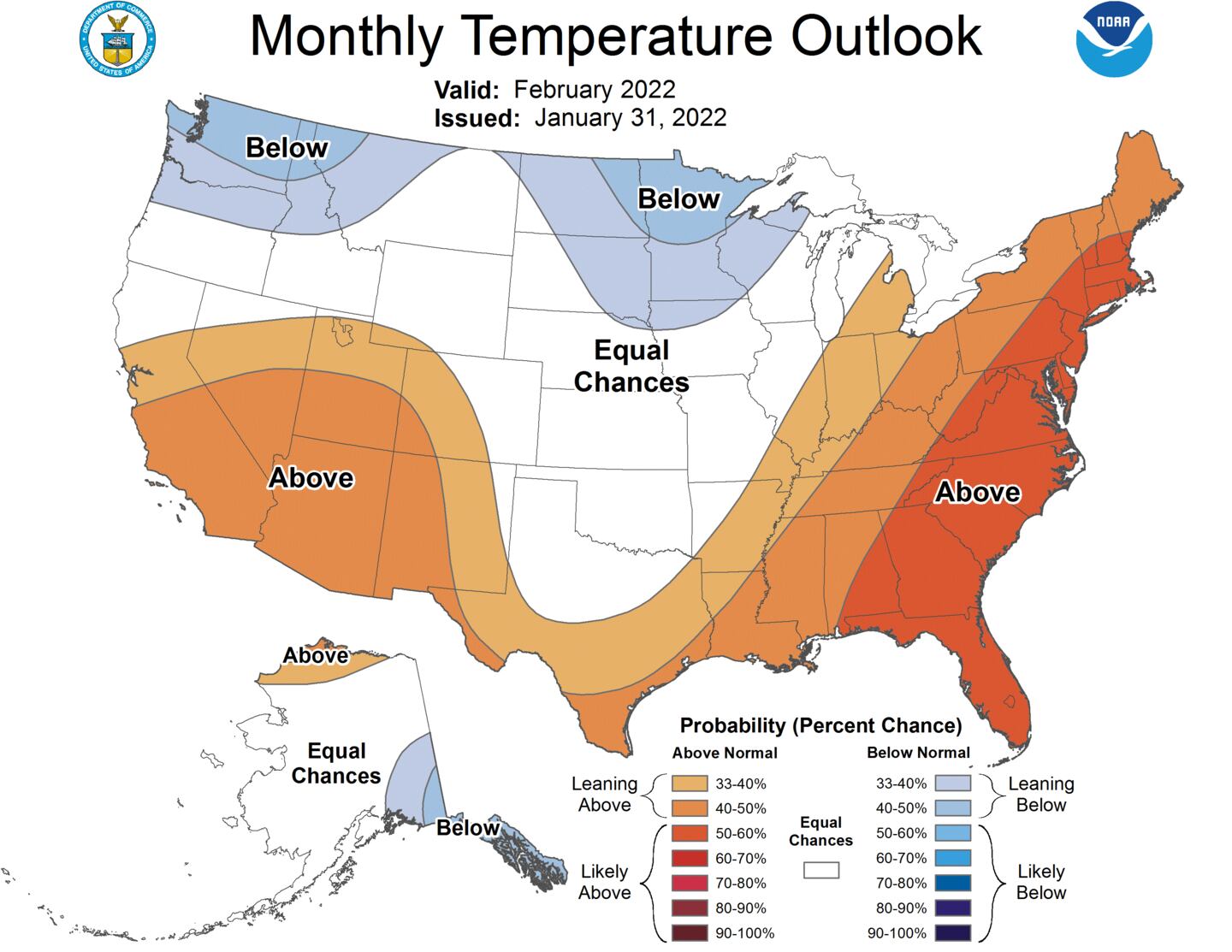
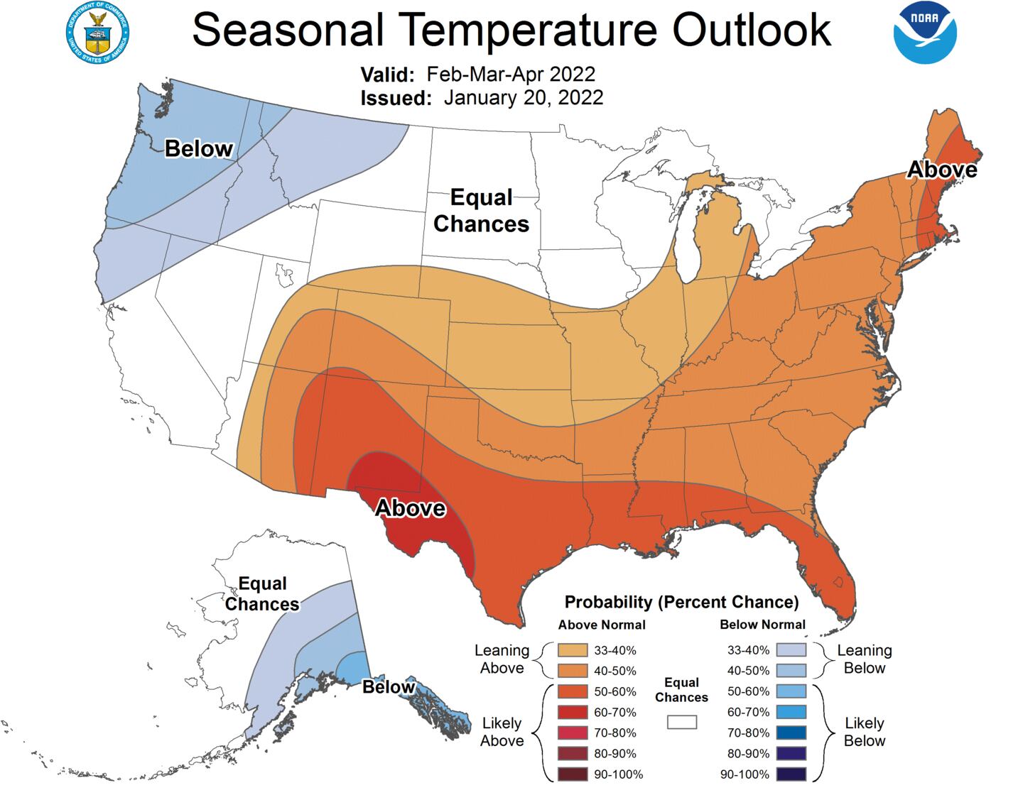
Below are the outlooks from NOAA’s Climate Prediction Center. Both February 2022 and the Three-Month Outlook (Feb - April) indicate that above average temperatures are likely for the next 4-6 weeks.
Connect with Me!
Facebook: Christina Edwards WSB
Twitter: @ChristinaWSBwx
©2022 Cox Media Group


 Sign Up


