MONDAY, JANUARY 6 EVENING THOUGHTS:
Let me preface this by saying, this is still not a “milk, eggs, bread” drill.
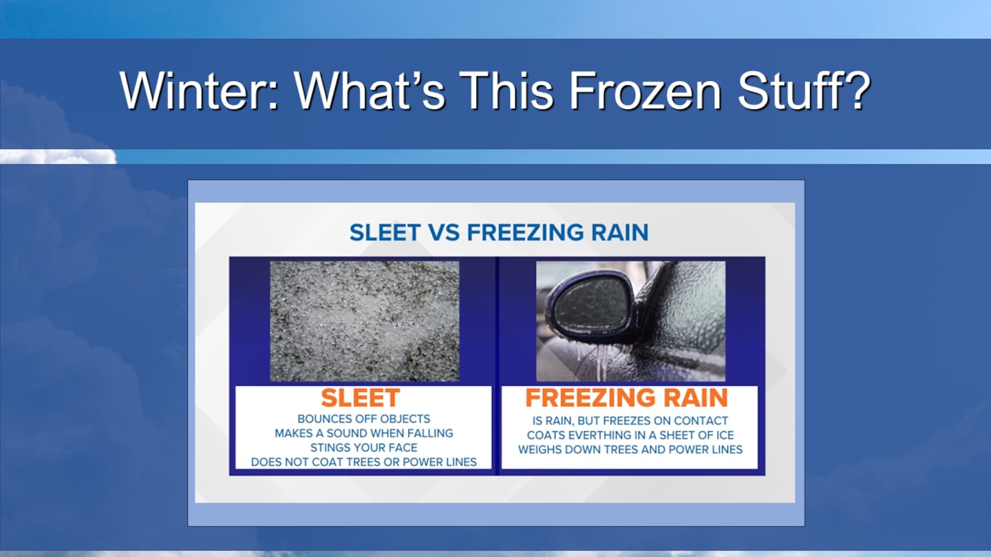
BUT, I will say that frozen precipitation -- including freezing rain, sleet, and yes, snow -- are a possibility for Metro Atlanta Friday through Saturday morning.
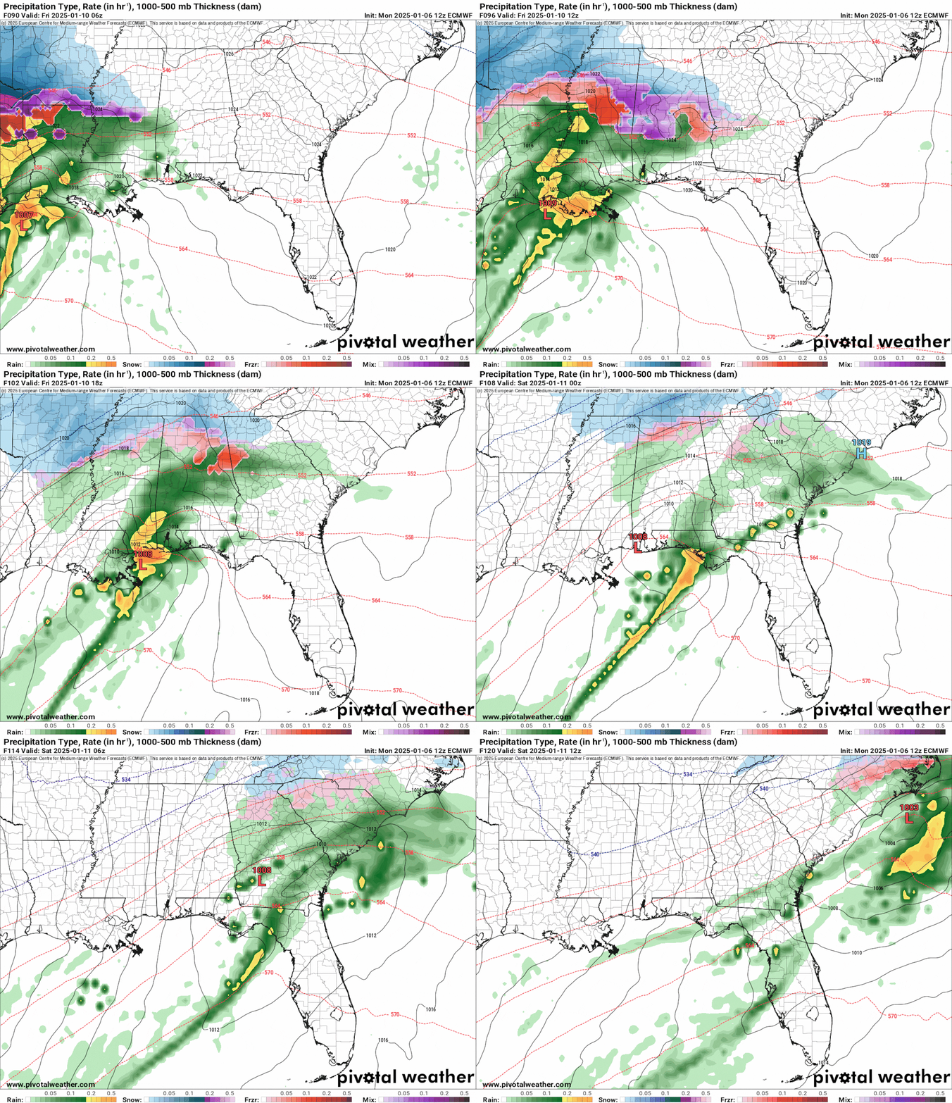
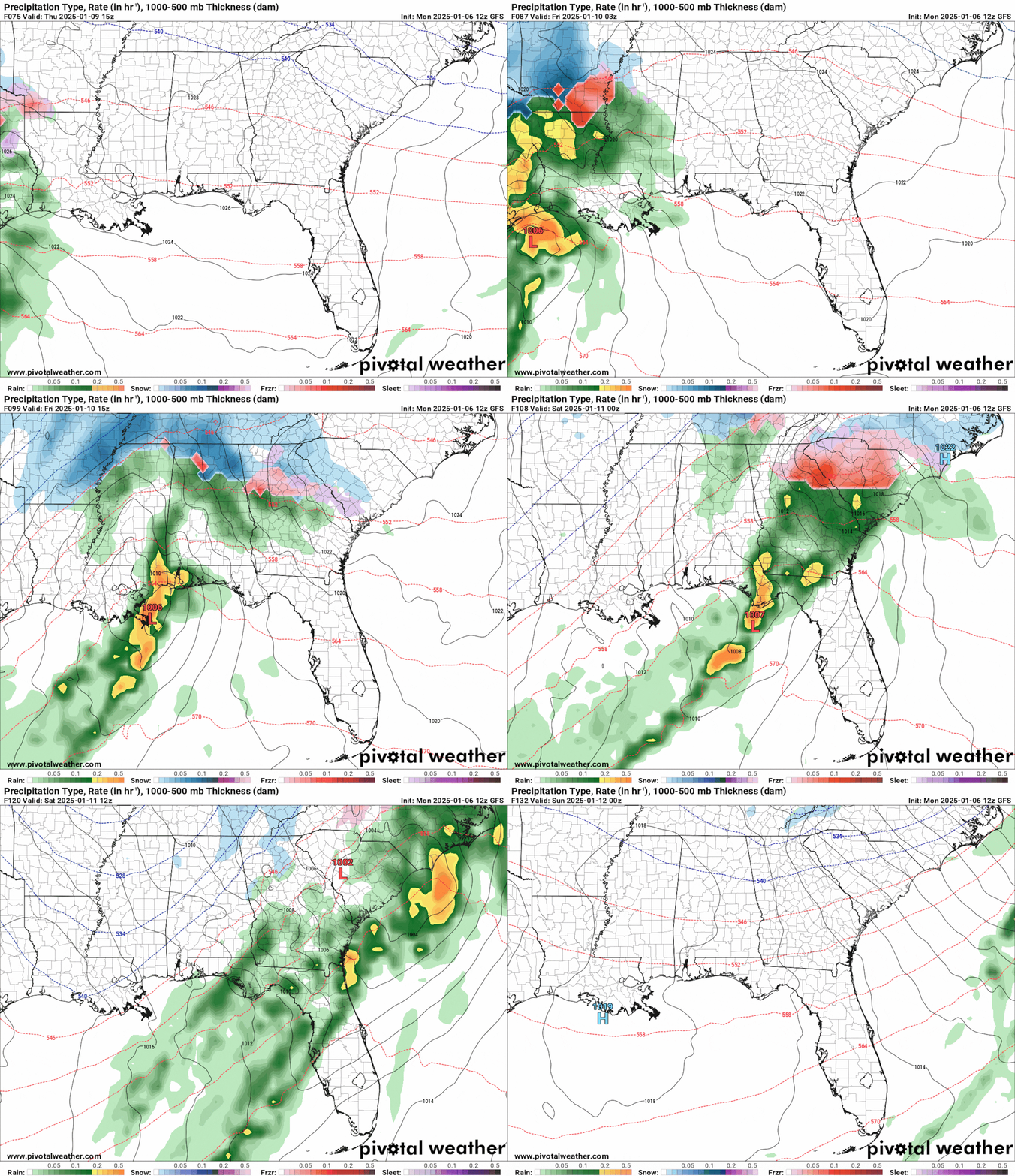
For the past few days, long range models are consistent on honing in on a Southern Low set up on Friday and Saturday, January 10-11.
This particular Southern Low will continue to hug the Gulf Coast, as opposed to drifting further north into Alabama and Georgia.
As a result, it is possible that enough warm air is able to travel from the Gulf into the middle atmosphere over North Georgia to prevent a complete snowstorm from developing.
Instead, a mixed bag of precipitation is possible, especially over the I-20 corridor. It is possible that sleet as well as freezing rain will fall along I-20 and areas south, with a cold rain falling south of Newnan and Griffin.
Below is the ECMWF, or the “Euro Model”:
Below is the GFS, or the “American Model”:
SO YOU’RE SAYING THERE’S A CHANCE...
Yes, there is a chance of snow... North I-20. In fact, some of our northern suburbs may get up to 1 inch of snowfall, while the North Georgia Mountains will receive 1 to 3 inches of snow.
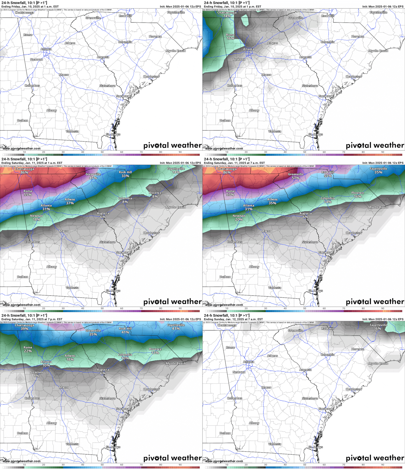
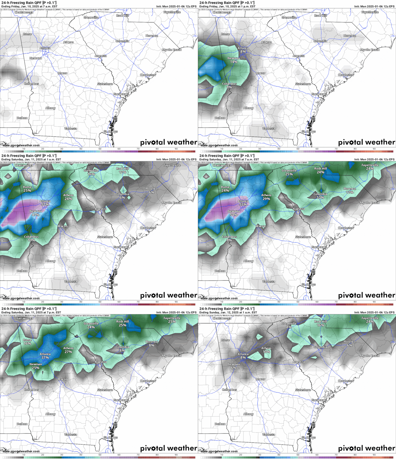
Below is the Ensemble ECMWF, which is created by running the ECMWF numerous times with different initial conditions (ie, temperature, pressure, dewpoint, etc).
For Friday night into Saturday morning, the chance for 1+ inch snowfall is greatest north of I-20, where some of the suburbs have as much as a 50 percent chance for an inch of snow.
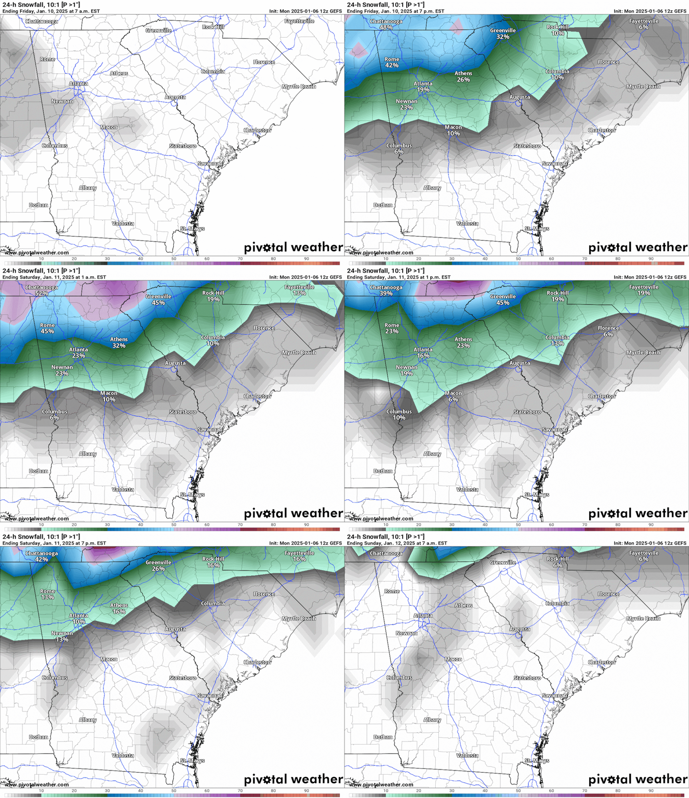
Below is the Ensemble GFS, which is created by running the GFS numerous times with different initial conditions (ie, temperature, pressure, dewpoint, etc).
For Friday night into Saturday morning, the chance for 1+ inch snowfall is greatest north of I-20, where some of the suburbs have as much as a 40 percent chance for an inch of snow.
HOWEVER, the risk remains for icy conditions, including freezing rain and sleet.
The European Model is indicating a high likelihood of freezing rain developing along the I-20 corridor. The threat of freezing rain is as high as 50% for the I-20 area as well as all of the Perimeter.
If this happens, freezing rain would significantly decrease the amount of snowfall for the Metro Atlanta area, as it signifies the presence of a “warm nose” in the atmosphere, which melts the snow before it refreezes into ice pellets (sleet) or on contact with the ground (freezing rain).
In addition, freezing rain would create high impact conditions on local travel, as it is very difficult -- if not impossible -- to travel on iced-over roads.
If freezing rain accumulations are more than half an inch, this may begin to impact trees and powerlines, which will sag under the weight of the ice.
AS OF MONDAY EVENING, WHAT DO I KNOW FOR FRIDAY & SATURDAY:
I know that this winter storm will move through Metro Atlanta FRIDAY MORNING THROUGH SATURDAY MORNING.
If the Gulf Low stays further south, a wintry mix -- including freezing rain, sleet, and snow -- will impact portions of Metro Atlanta, particularly the I-20 corridor.
If the Gulf Low travels a little further north, more of Metro Atlanta will be subjected to a cold rain.
DO YOU HAVE PLANS FOR FRIDAY AND SATURDAY?
Don’t cancel them just yet, but keep an eye on the forecast through Wednesday -- make your adjustments based on the information I and my fellow meteorology colleagues have by Wednesday morning. You should be able to make a go/no go call by then.
Cheers!
Talk Up A Storm With Me!
Facebook: Christina Edwards WSB
Instagram: ChristinaWSBwx
Twitter: @ChristinaWSBwx
TikTok: @ChristinaEdwards955WSB
©2025 Cox Media Group


